To properly protect forests and evaluate the state of natural resources, conservation practices and environmental policies, it is important to have accurate information on an area’s forest extent.
One of the challenges facing researchers when it comes to evaluating the accuracy of forest extent, however, is that models use different remote sensing products that may have different definitions for what determines forest extent. In addition, on the ground surveys may sometimes come into conflict with what remote, satellite-based products are describing as forests.
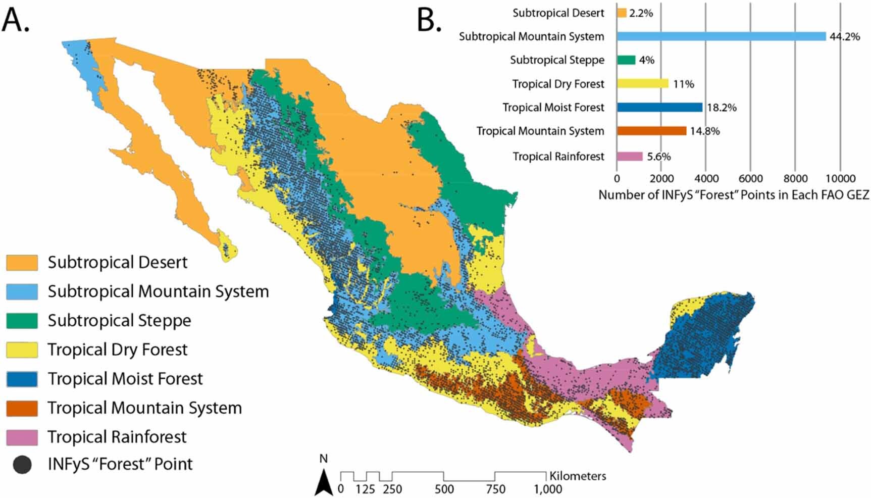
To help quantify this problem, a group of researchers from the University of Delaware teamed up with an international group of collaborators. Together, they looked at forest extent estimates from seven regional and global land or tree cover remote sensing products across Mexico, using two independent forest inventory datasets gathered by researchers on the ground—one on a national level and one on a local level—to verify the accuracy of the remote sensing products.
Using this information, they were able to develop a forest extent agreement map for Mexico, combining the seven products and the two datasets and identifying the consensus areas of agreement in their estimates.
The research is published in the journal Environmental Research Letters.
The lead author on the paper was Dustin Braden, who received his master’s degree from UD in 2023. Pinki Mondal, assistant professor in the Department of Geography and Spatial Sciences in UD’s College of Earth, Ocean and Environment and one of Braden’s advisors, was a co-author on the paper. During his time at UD, Braden was co-advised by Mondal and Rodrigo Vargas, professor of Ecosystem Ecology and Environmental Change in UD’s College of Agriculture and Natural Resources and Director of the Water Science and Policy program.
Using the different data, the researchers were able to find areas where the satellite products agreed on forest extent and where they disagreed—finding that high agreement tended to occur in heavily forested areas such as the Yucatan Peninsula and mountain areas in the Sierra Madre Oriental and Sierra Madre Occidental. High disagreement tended to occur in complex ecological zones such as the tropical dry forest and subtropical mountain system, where the varied tree cover can lead to inconsistencies in remote sensing analysis.
Braden said that, ideally, the researchers would like to have high correlation between the remote sensing products and the on the ground data but admitted that is a pretty lofty goal.
“There’s always going to be differences just because they’re different methods,” said Braden. “What someone is doing on the ground all day, walking through these places and measuring these data versus what the satellite can pick up, it’s always going to be a little bit different which just makes sense.”
However, now that they’ve identified where the products agree and where they disagree, further research can be taken to see what exactly is causing the disagreement. The information could also be helpful to researchers on the ground who are collecting data for Mexico’s National Forest Inventory.
“Maybe the researchers collecting data might use something like this to say, ‘Ok, here’s this region where some products from satellites are identifying it as forested and some aren’t. We should probably get some better data here, on the ground, to see what exactly is happening,'” said Braden.
“There’s a whole bunch of reasons they might be getting confused. Satellites might be misidentifying shrubs as forest or, for example, they might just not see trees where there are trees. So, that’s a useful insight that goes beyond the national forest inventory data.”
More information:
Dustin Braden et al, Estimating forest extent across Mexico, Environmental Research Letters (2023). DOI: 10.1088/1748-9326/ad193e
Citation:
Researchers develop forest extent map for Mexico (2024, April 23)
retrieved 24 April 2024
from https://phys.org/news/2024-04-forest-extent-mexico.html
This document is subject to copyright. Apart from any fair dealing for the purpose of private study or research, no
part may be reproduced without the written permission. The content is provided for information purposes only.