Devastating tornadoes tore across parts of eastern Nebraska and northeast Texas Friday as a multi-day severe thunderstorm event ramped up in the central United States.
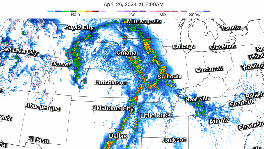
Storms began firing off across parts of the Plains and South early Friday afternoon with multiple tornadoes observed by mid-afternoon in Nebraska – including at least one that tracked near Lincoln and west of Omaha. The National Weather Service then issued a tornado emergency as the storm tracked just to the west of Omaha – the strongest type of tornado warning that means a deadly tornado is confirmed.
A tornado roared through the outskirts of Lincoln, churning up debris and crossing part of I-80 in the process. An overturned tractor-trailer, blown over by the storms, brought traffic to a slow crawl on I-80 northeast of the city, Nebraska traffic cameras showed.
At least two tornadoes were observed in Texas Friday afternoon, one northeast of Waco. Video of the twister posted to social media showed it churning across a large field.
The tornado threat will continue to increase through the evening.
It’s all part of classic springtime setup for severe weather. Moist air from the Gulf of Mexico is flowing into the central U.S. as heat builds in the region, priming the atmosphere for robust storms.
Some locations are facing down a severe thunderstorm threat spanning two or three consecutive days.
Dallas; Kansas City, Missouri; Des Moines, Iowa; and Omaha, Nebraska, are just a few cities that could be hit by multiple rounds of severe thunderstorms through Sunday.
Here’s where to expect these hazardous storms each day:
Friday: Plains, Mississippi Valley, Midwest
A fresh round of severe thunderstorms bubbled to life late Friday morning in parts of the Plains, prompting tornado warnings in Texas.
The quickly developing storms prompted the Storm Prediction Center to raise the severe risk in the region.
A Level 3 of 5 risk of severe thunderstorms in place in Nebraska, Iowa, Kansas and Missouri was expanded south into Oklahoma, Arkansas and Texas early Friday afternoon.
The storms in Texas are likely to build in scope and strength throughout the afternoon and evening, ultimately reaching into Oklahoma and Arkansas.
Severe thunderstorms fired up in eastern Nebraska early in the afternoon and later in the afternoon in Kansas. The storms will track east into Iowa and Missouri through the evening and into the overnight.
Damaging wind gusts, hail up to the size of baseballs and strong tornadoes – at least EF2-strength – are possible with any storm in the Level 3 of 5 risk area.
“Several factors appear to be supportive of a significant tornado event today,” the prediction centre warned Friday morning. The tornado risk will continue to increase into the evening hours.
Heavy rainfall with rates up to 2 inches per hour could cause flooding in parts of Texas, Oklahoma, Arkansas and Missouri.
Parts of Missouri were deluged with rain on Thursday, prompting flash flood warnings in the Springfield area, where more than half a month’s worth of rain fell. Additional heavy rainfall Friday could allow floodwaters to rise faster and pose an even greater hazard.
Saturday: Potential to be the most dangerous day
Saturday could be the most dangerous day of the four if certain atmospheric conditions align. The potential strength of storms hinges on how Friday night’s storms evolve and linger into Saturday morning.
“A complex but potentially significant severe weather episode is expected on Saturday,” the prediction center cautioned Friday.
If storms hang around in the morning hours, the atmosphere will not be able to fully recharge to unload widespread, dangerous storms. Damaging storms are still likely in this scenario, they could just fail to reach their peak potential strength.
But if storms quickly clear out Saturday morning, there won’t be much of a limit on how strong storms could become.
The most significant storms are possible starting in the afternoon in parts of the southern and central Plains, where a Level 3 of 5 risk of severe thunderstorms is in place. Widespread damaging wind gusts, hail up to the size of baseballs and strong tornadoes are the storms’ main hazards.
The tornado threat could ramp up considerably through the late afternoon and evening hours with “multiple strong tornadoes” possible, according to the prediction center.
Damaging storms are possible outside of the greatest risk area in a huge area of the country from the Great Lakes to southern Texas.
A “significant rainfall event” could unfold Saturday, the Weather Prediction Center warned. Some locations could record close to 5 inches of rain in a short period and dangerous flash flooding could result. A handful of locations caught under multiple rounds of gushing rainfall could have totals approach the 8-inch mark.
A Level 3 of 4 risk of excessive rainfall is in place for a large portion of Oklahoma – including Oklahoma City and Tulsa – and smaller parts of Kansas and Texas. Intense rainfall could force streams to overflow their banks and flood roadways.
Sunday: Plains, Mississippi Valley, Midwest
Damaging storms are possible from Texas to Wisconsin Sunday. But the exact timing, extent and strength of these storms will depend heavily on how Saturday night’s storms behave.
If the atmosphere is able to recharge following morning storminess, new severe thunderstorms will start to bubble up in the afternoon. Areas from northeastern Texas to southern Iowa and western Illinois face the greatest chance for damaging storms.
The storms could unload damaging wind gusts and large hail, but an isolated tornado or two is also possible.
Some storms, especially in the southern portion of the risk area, could remain severe as they push east Sunday night.
Heavy, flooding rainfall is possible, especially in parts of the Lower Mississippi Valley.
By Monday, severe weather is forecast to become much more isolated. Any developing storms may be confined to the Gulf Coast.
CNN Meteorologist Robert Shackelford contributed to this report.