
A coastal storm continues to strengthen off the coastline of New England Tuesday afternoon.
The storm is expected to take a path south and then east of the Atlantic coastline of Nova Scotia. While not coming directly through the Maritimes, it does get close enough to possibly swipe some of the heavier snow into Atlantic coastal Nova Scotia. Snow squalls behind the storm will accumulate additional snowfall amounts for the north shore of Nova Scotia, Cape Breton Highlands, and eastern Prince Edward Island Wednesday afternoon through Thursday morning.
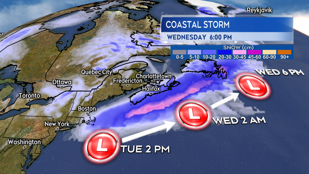 The heavy snow with the storm skirts the Atlantic coastline of Nova Scotia on the way for a more direct impact in eastern Newfoundland.
Timing
Snow develops west to east Tuesday afternoon through Tuesday evening for Nova Scotia. Not much more than some flurries are expected to brush into the south of New Brunswick and P.E.I. The snow clears western Nova Scotia before sunrise on Wednesday. The snow clears eastern areas of Nova Scotia through Wednesday morning. Snow squalls will develop off the Gulf of St. Lawrence Wednesday afternoon through Thursday morning bringing additional snow amounts to eastern P.E.I., the north shore of Nova Scotia, and Inverness/Victoria Counties of Cape Breton. Additional snow amounts in the snow squalls could range from 1 to 5 cm at lower elevations to in excess of 10 cm in more mountainous terrain.
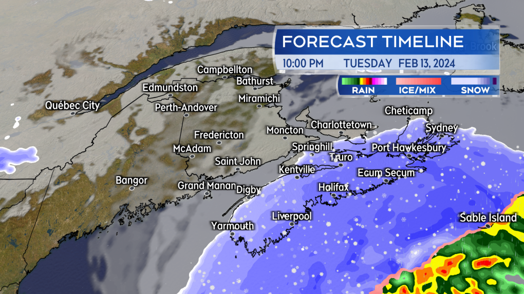 Snow will be blowing across Nova Scotia by late Tuesday evening. The snow will heaviest on the Atlantic coastline.
Snow amounts
Atlantic coastal Nova Scotia walks the razor’s edge with some of the heavier snow as the system passes through. The south shore through Halifax and up to Sydney will have the best shot of picking up snow totals of at least 15 cm. I also have Pictou, Antigonish, and Inverness/Victoria Counties in Cape Breton with 10 to 25 cm of snow, but for those areas that includes the additional snow squalls off the Gulf of St. Lawrence running through Thursday morning. Totals of more than 10 cm for those areas may be more localized, depending on how the snow squalls come in.
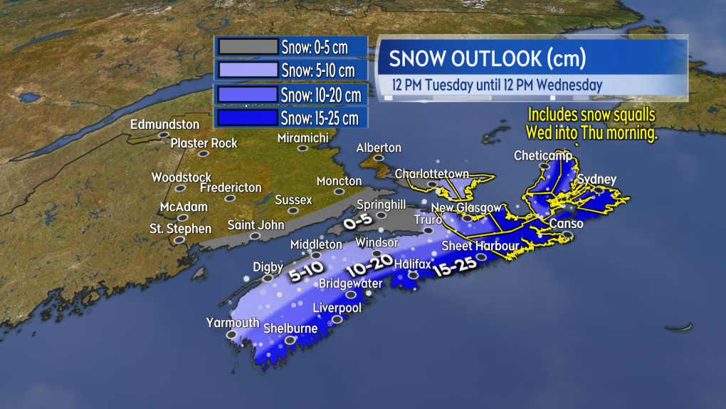 Possible snow amounts are pictured. For eastern areas of Nova Scotia and eastern Prince Edward Island, this includes additional snow squalls that could run into Thursday morning.
Wind
A northerly wind with peak gusts of 40 to 70 km/h, except up to 80 km/h on exposed areas of the Atlantic coastline of Nova Scotia, will accompany the falling snow Tuesday evening and night. The gusty wind will create periods of blowing and drifting snow. Visibility may come down to or below one-kilometre for periods of time and will improve as the snow clears.
A gusty northwest wind will continue for the Maritimes Wednesday into Thursday. That northwest wind could carry additional snow squalls off the Gulf of St. Lawrence for eastern areas of P.E.I. and eastern areas of Nova Scotia. Some flurries off the Bay of Fundy will also be possible for western Nova Scotia.
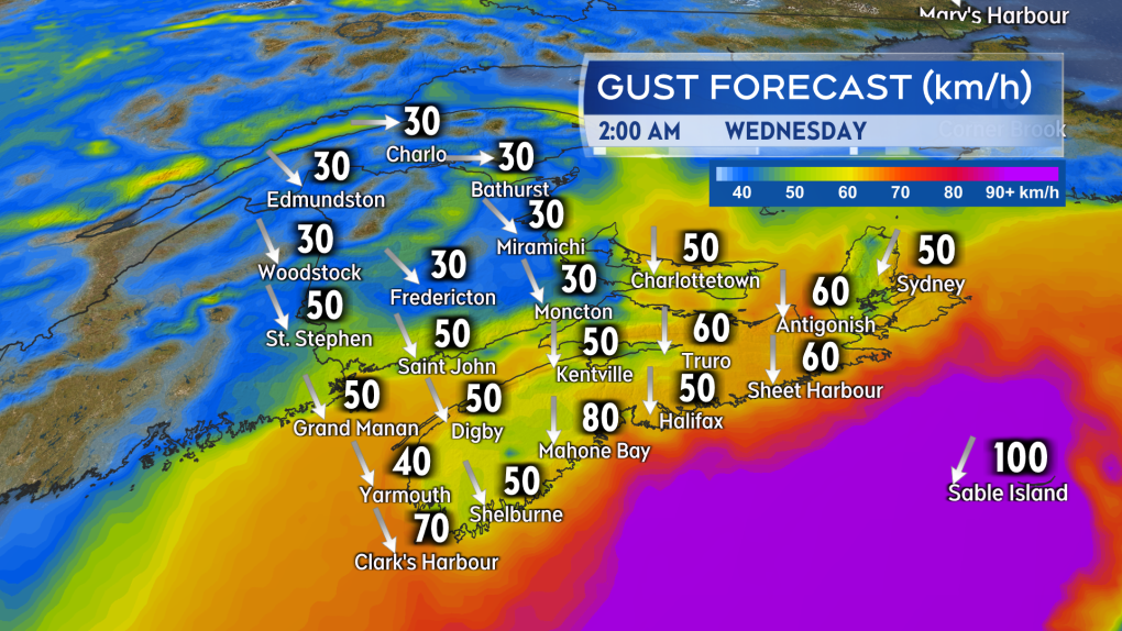 While largely below warning criteria, the wind will be gusty enough to create periods of blowing and drifting snow.
Weather alerts
A winter storm warning has been issued for Atlantic coastal Nova Scotia as well as Pictou, Antigonish, and southern Inverness Counties. A winter storm watch stands for Victoria and northern Inverness Counties in Cape Breton. No weather alerts are in effect for New Brunswick and Prince Edward Island, which are largely expected to remain out most of the inclement weather associated with the passing storm.