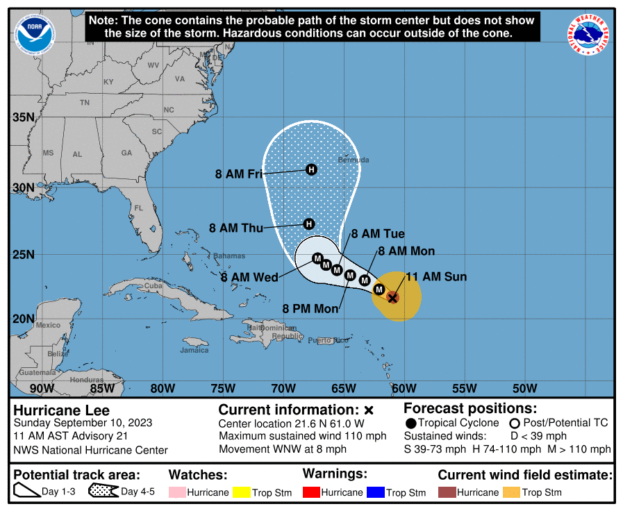
Hurricane Lee is expected to restrengthen in the coming days, the National Hurricane Center said Sunday.
National Oceanic and Atmospheric Association/Screenshot by NPR
hide caption
toggle caption
National Oceanic and Atmospheric Association/Screenshot by NPR

Hurricane Lee is expected to restrengthen in the coming days, the National Hurricane Center said Sunday.
National Oceanic and Atmospheric Association/Screenshot by NPR
Hurricane Lee, a powerful Category 3 storm, is expected to steer well north of Puerto Rico and the Virgin Islands over the next couple of days, the National Hurricane Center said. But the hurricane is expected to gather strength and could bring dangerous surf conditions along the U.S. East Coast beginning on Sunday.
The hurricane, packing maximum sustained winds of close to 110 mph with higher gusts, is already causing life-threatening rip currents affecting parts of the Lesser Antilles, the British and Virgin Islands, Puerto Rico, Hispaniola, the Turks and Caicos Islands, the Bahamas and Bermuda, forecasters said Sunday morning.
Still, no coastal watches or warnings were in effect at the time.
Lee’s forecast has fluctuated wildly in recent days. It quickly reached Category 5 strength over record high water temperatures in the Atlantic before being downgraded early Saturday. But it’s expected to restrengthen over the next couple of days.
A Category 3 storm, considered a major hurricane, can cause devastating damage to well-built framed homes, knock down trees, as well as cut off power and water supply for several days.

“It remains too soon to know what level of impacts, if any, Lee might have along the East Coast, Atlantic Canada or Bermuda late next week, especially since the hurricane is expected to slow down considerably over the southwestern Atlantic,” the center said in its 11 a.m. ET advisory on Sunday.
Dangerous surf and rip currents are expected to begin along much of the East Coast later Sunday and worsen throughout the week as Lee grows in size, forecasters said.

