To be tropical, or not to be tropical
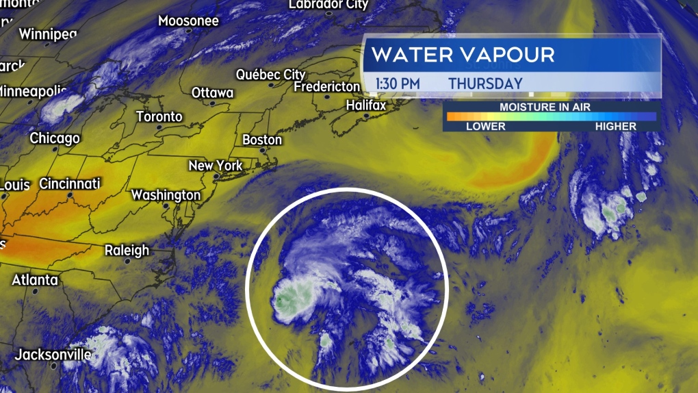
A low-pressure system currently sitting to the west of Bermuda is being given a 20 per cent chance of tropical development by the National Hurricane Center in the United States.
Chris Fogarty, program manager of the Canadian Hurricane Centre, describes the system as having “a mixture of the traits of a typical fall storm and a tropical storm.” They are in discussion with the National Hurricane Center and if it becomes more “tropical-storm-like” over the next 24 hours, it is possible it will be designated with a name.
Regardless, Chris cautions that rain and wind from the system will come across the Maritimes on Saturday. Environment Canada anticipates issuing rainfall warnings and possibly wind warnings.
The low-pressure system moving into the Maritimes from the south for Saturday will have a tropical component to it.
Rainfall warnings and special weather statements
Satellite imagery is showing heavy sub-tropical moisture tied up in the storm. The presence of that moisture increases the risk of higher rainfall rates and downpours.
Current guidance for the system shows possible areas of rain totals reaching 50 to 100 mm in the Maritimes. At this time, Halifax County and west in Nova Scotia looks most at risk for the heaviest rain. Halifax County, the South Shore, and Annapolis County are all under a rainfall warning advising on totals that could reach 40 to 100 mm.
The rest of Nova Scotia, southern and eastern areas of New Brunswick, and Prince Edward Island are under a special weather statement. Rain for those areas could reach 30 to 50 mm. Both the warnings and statements advise that the rain could come in the form of downpours.
The rain develops Friday night into Saturday morning, continues for Saturday afternoon and then mostly clears in the evening. Scattered showers are expected to follow for Saturday night and Sunday.
Wind gusts of 70 to 90 km/h may develop on the Atlantic coastline of Nova Scotia by Saturday morning. Gusts for northern Inverness County in Cape Breton could reach over 100 km/h on Saturday due to the topography of the Highlands. Wind is expected to diminish Saturday evening and night.
 Lots of water vapour present with the low-pressure system on satellite imagery. That increases the risk of higher rain totals and downpours with it.
Atlantic hurricane season update
Despite predictions for a very active hurricane season, it has been remarkably quiet mid-August into the start of September. A detailed discussion by the Department of Atmospheric Science, Colorado State University, explores a number of possible reasons for this.
Those are given as:
- A more northward position of the African monsoon which produces the thunderstorms that are often the start of a tropical storm or hurricane. The more northerly positions means that more of those thunderstorms are emerging over relatively cooler waters of the eastern Atlantic instead of the primed, warmer waters closer to the equator.
- Upper-tropospheric warming. OK, that’s a mouthful, but in a nutshell it means that air is warmer aloft in the atmosphere. When warmer air sits aloft, it acts like a cap or lid. That makes it harder for thunderstorms to sustain themselves long enough to organize around a centre of low pressure which would then go on to become a tropical storm or hurricane.
- Too much wind shear over the eastern Atlantic. When winds are too strong or change in direction too much moving aloft in the atmosphere, they can act to tear apart a developing area of thunderstorms before it can form into a tropical weather system.
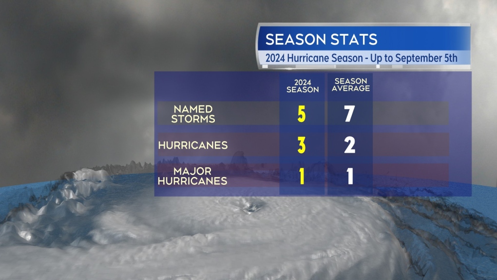
 The 2024 hurricane season compared to averages up to Sept. 5.
Speaking with Ian Hubbard, a meteorologist for Environment and Climate Change Canada, the agency has also identified those factors as contributing to a slow down in the season. Ian did point out for the season, we have had five named storms, three hurricanes, and one major hurricane. That is close to the average for this point in the season of seven named storms, two hurricanes, and one major hurricane.
It is also important to note that the peak of the season is still ahead this month and hurricane season doesn’t end until Nov. 30. A long season with more time available for further tropical storms and hurricanes to develop.

